


| Part #: | 700-00167-015 |
|---|---|
| Model: | EX600 |
| Desc: | MultiFunction Display |
| OEM: | Avidyne |
| NSN: | |
|---|---|
| Sched-B: | 9014208040 |
| ECCN: | 7A994 |
| Cage Code: | 1SVC7 |
| Price | Condition | Availability | Stock Info | |
|---|---|---|---|---|
| Price | Cond. | Avail. | Stock Info | |
| REQUEST | SV OUTRIGHT | REQUEST LEAD TIME |
|
| Price | Condition | Availability | Stock Info | |
|---|---|---|---|---|
| Price | Cond. | Avail. | Stock Info | |
| REQUEST | SV OUTRIGHT | REQUEST LEAD TIME |
|
| Price | Condition | Availability | Stock Info | |
|---|---|---|---|---|
| Price | Cond. | Avail. | Stock Info | |
| REQUEST | SV OUTRIGHT | REQUEST LEAD TIME |
|
| Price | Condition | Availability | Stock Info | |
|---|---|---|---|---|
| Price | Cond. | Avail. | Stock Info | |
| $9,125.00 | SV OUTRIGHT | 1 IN STOCK |
Serial #: 21101524 [Details]
|
|
| $4,750.00 | SV EXCHANGE | 1 IN STOCK |
Serial #: 21101524 [Details]
|
| Price | Condition | Availability | Stock Info | |
|---|---|---|---|---|
| Price | Cond. | Avail. | Stock Info | |
| REQUEST | SV OUTRIGHT | REQUEST LEAD TIME |
|
| Price | Condition | Availability | Stock Info | |
|---|---|---|---|---|
| Price | Cond. | Avail. | Stock Info | |
| REQUEST | SV OUTRIGHT | REQUEST LEAD TIME |
|
| Price | Condition | Availability | Stock Info | |
|---|---|---|---|---|
| Price | Cond. | Avail. | Stock Info | |
| $8,995.00 | SV OUTRIGHT | 1 IN STOCK |
Serial #: 90118670 [Details]
|
|
| $4,750.00 | SV EXCHANGE | 1 IN STOCK |
Serial #: 90118670 [Details]
|
| Price | Condition | Availability | Stock Info | |
|---|---|---|---|---|
| Price | Cond. | Avail. | Stock Info | |
| REQUEST | SV OUTRIGHT | REQUEST LEAD TIME |
|
| Price | Condition | Availability | Stock Info | |
|---|---|---|---|---|
| Price | Cond. | Avail. | Stock Info | |
| REQUEST | SV OUTRIGHT | REQUEST LEAD TIME |
|
| Price | Condition | Availability | Stock Info | |
|---|---|---|---|---|
| Price | Cond. | Avail. | Stock Info | |
| REQUEST | SV OUTRIGHT | REQUEST LEAD TIME |
|
| Price | Condition | Availability | Stock Info | |
|---|---|---|---|---|
| Price | Cond. | Avail. | Stock Info | |
| $10,500.00 | SV OUTRIGHT | REQUEST LEAD TIME |
|
| Price | Condition | Availability | Stock Info | |
|---|---|---|---|---|
| Price | Cond. | Avail. | Stock Info | |
| REQUEST | SV OUTRIGHT | REQUEST LEAD TIME |
|
| Price | Condition | Availability | Stock Info | |
|---|---|---|---|---|
| Price | Cond. | Avail. | Stock Info | |
| REQUEST | SV OUTRIGHT | REQUEST LEAD TIME |
|
| Price | Condition | Availability | Stock Info | |
|---|---|---|---|---|
| Price | Cond. | Avail. | Stock Info | |
| REQUEST | NEW OUTRIGHT | REQUEST LEAD TIME |
|
| Price | Condition | Availability | Stock Info | |
|---|---|---|---|---|
| Price | Cond. | Avail. | Stock Info | |
| REQUEST | NEW OUTRIGHT | REQUEST LEAD TIME |
|
| Price | Condition | Availability | Stock Info | |
|---|---|---|---|---|
| Price | Cond. | Avail. | Stock Info | |
| REQUEST | RFQ | REQUEST LEAD TIME |
|
| Price | Condition | Availability | Stock Info | |
|---|---|---|---|---|
| Price | Cond. | Avail. | Stock Info | |
| REQUEST | RFQ | REQUEST LEAD TIME |
|
| Price | Condition | Availability | Stock Info | |
|---|---|---|---|---|
| Price | Cond. | Avail. | Stock Info | |
| REQUEST | SV OUTRIGHT | REQUEST LEAD TIME |
|
| Price | Condition | Availability | Stock Info | |
|---|---|---|---|---|
| Price | Cond. | Avail. | Stock Info | |
| REQUEST | SV OUTRIGHT | REQUEST LEAD TIME |
|
| Price | Condition | Availability | Stock Info | |
|---|---|---|---|---|
| Price | Cond. | Avail. | Stock Info | |
| REQUEST | NEW OUTRIGHT | REQUEST LEAD TIME |
|
| Price | Condition | Availability | Stock Info | |
|---|---|---|---|---|
| Price | Cond. | Avail. | Stock Info | |
| REQUEST | NEW OUTRIGHT | REQUEST LEAD TIME |
|
| Price | Condition | Availability | Stock Info | |
|---|---|---|---|---|
| Price | Cond. | Avail. | Stock Info | |
| REQUEST | NEW OUTRIGHT | REQUEST LEAD TIME |
|
| Price | Condition | Availability | Stock Info | |
|---|---|---|---|---|
| Price | Cond. | Avail. | Stock Info | |
| REQUEST | NEW OUTRIGHT | REQUEST LEAD TIME |
|
| Price | Condition | Availability | Stock Info | |
|---|---|---|---|---|
| Price | Cond. | Avail. | Stock Info | |
| REQUEST | NEW OUTRIGHT | REQUEST LEAD TIME |
|
| Price | Condition | Availability | Stock Info | |
|---|---|---|---|---|
| Price | Cond. | Avail. | Stock Info | |
| REQUEST | RFQ | REQUEST LEAD TIME |
|
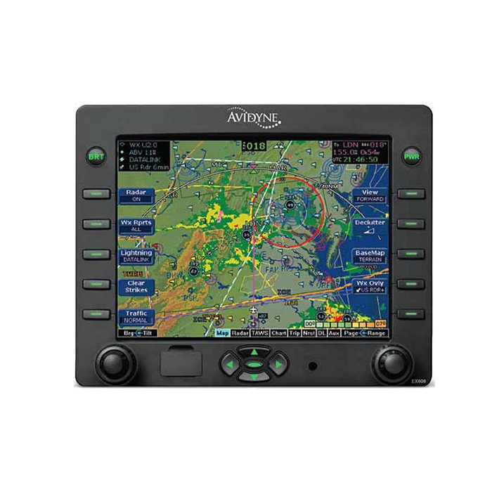
- Multi-Function Display
- High Resolution 5.8" LCD Diagonal Display
- Wide viewing range with over 40% more pixels than Avidyne's previous-generation MFD
- Designed to replace existing CRT-based radar indicators
- View datalink graphical weather information that is integrated with your flight plan moving map, lightning, traffic and terrain display
- Dedicated range, bearing and tilt controls and exclusive features like BeamView and TiltView
- World-wide datalink weather
- Interfaces with 19 different on-board weather radar systems
- Easy to update - databases are easily updated through the USB port on the front bezel
- Easy to upgrade - pin-for-pin replacement for EX500, provides a larger display and adds Map Panning capability
- Easy-to-use panning function
- Dedicated panning keys - four directional keys with center "QuickPan" key which toggles the display between the panned position and your present position
- Includes CMax™, providing a world-wide library of geo-referenced approach charts and airport diagrams that help manage and access critical flight information and reduce the amount of paper required on board
- CMax airport diagrams include 6,004 world-wide locations, 5,695 of which are geo-referenced charts
- Utilizing Jeppesen's trusted JeppView™ Electronic airway manual, CMax makes accessing an approach & viewing airport diagrams easy
- Charts can be loaded for nearby airports along your route from the Trip Page using the EX600's Auto-Fill™
- Informative Trip Page - easy access to vital information
- "Nearest to Destination" Page - shows graphical and decoded METARs at the destination and surrounding airports
- Displays color lightning, broadcast and 2-way satellite datalink weather
- Displays real-time color lightning overlaid on the moving map when interfaced to TWX670
- MLB700 broadcast datalink receiver gives comprehensive, graphical information about weather conditions all across the Continental US
- Using the WSI InFlight® Weather Service via SIRIUS, the EX600 displays high-resolution NOWrad® radar mosaic, Storm Track Vectors, Hail Warnings, AIRMETs, SIGMETs, graphical and textual METARs, TAFs, Temperatures and Winds Alfot, TFRs, & Lightning form WSI's lightning network
- International MLX770 Satellite datalink transceiver delivers worldwide satellite-based datalink weather
- Two-way text messaging available when interfaced to the MLX770 (via email connection or compatible SMS-capable mobile telephone)
- International weather products include METARs, TAFs, SAT IR, Lightning, and regionalized NEXRAD radar imagery
- CLICK HERE for an EX600 vs KMD850 Comparison.
FUNCTIONALLY
- Datalink Interface
- Avidyne MLB700 Broadcast Datalink Receiver - Using WSI InFlight Aviation Weather & SIRIUS Satellite Radio
- Heads Up Technologies XMD-076/A - Using Baron Services weather & XM Satellite Radio
- Avidyne MLX770 / MLX780 Two-Way Datalink Transceiver - Using Avidyne/WSI Services Weather & Text Messaging
- Vector-Graphic Moving Map
- Americas Jeppesen NavData
- International Jeppesen NavData - Optional
- GPS/FMS Interface
- ARINC 429 GAMA Graphics
- RS-232
- Heading Interface
- ARINC 407 - Synchro XYZ
- ARINC 429
- Electronic Approach Charts
- CMax - Jeppesen Electronic Airway Manual Charts
- European VFR Charts
- Airport Diagrams
- Lightning Interface
- Avidyne TWX670 Tactical Lightning Detection
- L3 WX-500 Stormscope Weather Sensor
- Traffic Interface
- Arinc 735 & RS-232
- Avidyne TAS600 / TAS610 / TAS620 TAS
- Ryan 9900B/9900BX TAS
- Honeywell KTA870 / KMH880 TAS/IHAS
- L3 Skywatch 497 / Skywatch HP TAS
- Garmin GTX330 TIS Transponder
- L3 791 TCAS I
- Honeywell CAS66A TCAS I
- Terrain Awareness
- Color-Contoured Terrain Base Map Built in - Americas Terrain & US Obstacle Data - International Terrain Data - Optional
- EGPWS/TAWS Interface - Optional (Class B)
- Honeywell MK V, VI, VII, VIII
- Honeywell KMH880 IHAS
- Honeywell KGP560 / KGP860
- Honeywell MK XXI / MK XXII (HTAWS)
- Radar Interface - Optional
- Collins WXR250 / 270 / 300
- Bendix RDR130 / 150 / 160
- Bendix RDR1100 / 1200 / 1300 / 1400
- Bendix RDS81 / 82/82VP / 84/84VP / 86/86VP
- Bendix/King RDR2000/2100
SPECIFICATIONS
| TSO: | C63c, C110a, C113, C118, C147, C157 | Display: | 5.8"D x 4.61"W x 3.48"H; 640 x 480 pixels |
| Weight: | 5.75 lbs. Fixed Wing Tray: 0.9 lbs Helicopter Tray: 4.1 lbs | Dimensions: | 4.93"H x 6.24"W x 10.99"D |
| Power: | Max 3.0A @ 28 VDC | Cooling: | Internal Forced Air Cooling Provided |
| Environmental: | DO 160E, To 50,000 ft., -20C to +55C Operating +70C Short Term |
| Part Number: | Description: |
|---|---|
| 700-00167-001 | No Radar Interface, Black, |
| 700-00167-002 | RDR1100/1200 Interface, Black |
| 700-00167-003 | RDR1300 Interface, Black |
| 700-00167-004 | RDR130/150/160 Interface, Black |
| 700-00167-005 | RDS8X/RDR2XXX Interface, Black |
| 700-00167-006 | WXR270/270A Interface, Black |
| 700-00167-011 | No Radar Interface, Gray, |
| 700-00167-012 | RDR1100/1200 Interface, Gray |
| 700-00167-013 | RDR1300 Interface, Gray |
| 700-00167-014 | RDR130/150/160 Interface, Gray |
| 700-00167-015 | RDS8X/RDR2XXX Interface, Gray |
| 700-00167-016 | WXR270/270A Interface, Gray |
| Serial # | 90118670 |
|---|---|
| Condition | SV |
| Mods | - |
| Tag Date | 09/10/25 |
| Shop | Duncan Aviation - Lincoln |
| Warranty | 6 Months |
| Price | Condition | Status |
|---|---|---|
| $9,125.00 | SV OUTRIGHT | 1 IN STOCK |
| $4,750.00 | SV EXCHANGE | 1 IN STOCK |
| Price | Condition | Status |
|---|---|---|
| $8,995.00 | SV OUTRIGHT | 1 IN STOCK |
| $4,750.00 | SV EXCHANGE | 1 IN STOCK |
| Price | Condition | Status |
|---|---|---|
| REQUEST | SV OUTRIGHT | REQUEST LEAD TIME |
| Price | Condition | Status |
|---|---|---|
| REQUEST | SV OUTRIGHT | REQUEST LEAD TIME |
| Price | Condition | Status |
|---|---|---|
| REQUEST | SV OUTRIGHT | REQUEST LEAD TIME |
| Price | Condition | Status |
|---|---|---|
| REQUEST | SV OUTRIGHT | REQUEST LEAD TIME |
| Price | Condition | Status |
|---|---|---|
| REQUEST | SV OUTRIGHT | REQUEST LEAD TIME |
| Price | Condition | Status |
|---|---|---|
| REQUEST | SV OUTRIGHT | REQUEST LEAD TIME |
| Price | Condition | Status |
|---|---|---|
| REQUEST | SV OUTRIGHT | REQUEST LEAD TIME |
| Price | Condition | Status |
|---|---|---|
| REQUEST | SV OUTRIGHT | REQUEST LEAD TIME |
| Price | Condition | Status |
|---|---|---|
| $10,500.00 | SV OUTRIGHT | REQUEST LEAD TIME |
| Price | Condition | Status |
|---|---|---|
| REQUEST | SV OUTRIGHT | REQUEST LEAD TIME |
| Price | Condition | Status |
|---|---|---|
| REQUEST | SV OUTRIGHT | REQUEST LEAD TIME |
| Price | Condition | Status |
|---|---|---|
| REQUEST | NEW OUTRIGHT | REQUEST LEAD TIME |
| Price | Condition | Status |
|---|---|---|
| REQUEST | NEW OUTRIGHT | REQUEST LEAD TIME |
NSN: 7025-01-649-7888
| Price | Condition | Status |
|---|---|---|
| RFQ | RFQ | RFQ |
| Price | Condition | Status |
|---|---|---|
| RFQ | RFQ | RFQ |
| Price | Condition | Status |
|---|---|---|
| REQUEST | SV OUTRIGHT | REQUEST LEAD TIME |
| Price | Condition | Status |
|---|---|---|
| REQUEST | SV OUTRIGHT | REQUEST LEAD TIME |
| Price | Condition | Status |
|---|---|---|
| REQUEST | NEW OUTRIGHT | REQUEST LEAD TIME |
| Price | Condition | Status |
|---|---|---|
| REQUEST | NEW OUTRIGHT | REQUEST LEAD TIME |
| Price | Condition | Status |
|---|---|---|
| REQUEST | NEW OUTRIGHT | REQUEST LEAD TIME |
| Price | Condition | Status |
|---|---|---|
| REQUEST | NEW OUTRIGHT | REQUEST LEAD TIME |
| Price | Condition | Status |
|---|---|---|
| REQUEST | NEW OUTRIGHT | REQUEST LEAD TIME |
| Price | Condition | Status |
|---|---|---|
| RFQ | RFQ | RFQ |
Click on a question below to see the answer. If you have a question about this model that is not answered below, please contact questions@seaerospace.com
Why do some parts indicate "REQUEST" or “RFQ” on the Southeast Aerospace website?
In relation to NE (New) parts, many OEMs change their prices and availability without any notice to dealers or the industry. Therefore, through the REQUEST or RFQ indication, we ask that customers contact us for the most accurate price and availability.
In relation to SV & OH parts, the used parts aftermarket in the aviation industry is not an infinite supply. It is a dynamic, constantly changing market that is significantly affected by and susceptible to highs and lows in supply and demand. Therefore, although we attempt to, at times, we are unable to predict the exact moment when an item may be available. Once again, through the REQUEST or RFQ indication on our website, we ask that customers contact us for the most current and accurate price and availability.
