| Part #: | |
|---|---|
| Model: | GNC-300XL |
| Desc: | IFR GPS/Comm |
| OEM: | Garmin |
| NSN: | |
|---|---|
| Sched-B: | 8526910010 |
| ECCN: | |
| Cage Code: | 0TRC3 |
NO LONGER AVAILABLE, INFORMATION IS FOR REFERENCE ONLY

GNC 300XL
- IFR certified GPS/Comm with moving map
- 760 channel comm with 5 watt minimum transmitter power
- Comm features include auto squelch control, stanadard headset output with sidetone and audio leveling, stuck mike transmission timeout, emergency channel select, 'autotune' frequency selection from database card
- Front loading data card entry
- 12 parallel channel GPS receiver
- Interfaces with most flight control, EFIS, HSI and othe cockpit systems
- Americas, International, or Worldwide Database coverage available
- Jeppesen database includes airports, VORs, NDBs, intersections, Comm frequencies, runways, FSS/ARTCC, MSA, SUA, approaches, SIDs/Stars
- 1000 user defined waypoints
- 20 reversible routes of up to 31 waypoints each
- Stoarge for comments on up to 250 waypoints
- 9 user checklists of up to 30 items each
- 9 schedules user messages
SPECIFICATIONS
| Emergency Search: | 9 nearest airports, VORs, NDBs, intersections, or user waypoints; 2 nearest FSS with frequncies; 2 nearest ARTCC frequencies | Alarms: | Arrival, Proximity, Timers, SUAs less than 10 minutes, 2NM and inside SUA |
| Receiver: | PhaseTrac 12 tracks and uses up to 12 satellites to compute amd update position | Acquisition Time: | 15 seconds (warm), 45 seconds (cold) |
| Update Rate: | 1/second, continuous | Accuracy: | 15 meters (position) |
| Interfaces: | ARINC 429, RS232, plotting (NMEA 0183 v2.0), Aviation, PC interface, altitude serializer, fuel sensor, fuel/air data computer, gray code, serial data | Map Datums: | 124 predefined, 1 user defined |
| Size: | 6.25 x 2 x 5.8 inches | Weight: | 41 ounces |
| Certification: | TSO C37d Class 4 (VHF Transmitter) TSO C38d Class C (VHF Receiver) TSO C129a, Class A1 (en route, terminal and approach) | VHF Transceivr Performance: | 760-channel 118-136.975 MHz 5 watt minimum transmitter power |
| Comm Features: | Auto squelch control, standard headset output with sidetone and audio leveling, stuck mic transmission timeout, emergency channel select, "autotune" frequency selection | Navigation Features: | Search and rescue operation (ladder search), pilot-defined course selection and waypoint hold, closest point of appraoch, departure and arrival frequencies |
| Planning Features: | True airspeed, density altitude, winds aloft, RAIM availability, Sunrise/Sunset calculations, and trip, fuel and VNAV planning | Dynamics: | Velocity: 999 knots Acceleration: 3G |
| Display: | 80 x 240 double super twist nematic with six times the contract of typical DSTN displays. Automatic contrast adjustment with reverse video display mode for exceptional readability in direct sunlight or at night | Power Source: | 10-15 VDC, optional rechargeable battery, 115-230 VAC with optional AC adpater for GPS simulator operation |
| Moving Map Features: | 14 map scales from 0.5 to 300 nm, with nearby waypoints, navaids and sectorized airspace, runway, and navigation data displayed. Autozoom feature automatically keeps present position and destination on the map, with user-selectable track up, north up or DTK up display, map decluttering by item and scale | Data Storage: | Internal battery retains stored data up to 5 years |
| Part Number: | Description: |
|---|---|
| 011-00433-00 | IFR GPS/Comm |
| 010-00161-00 | System P/N, IFR GPS/Comm |
| 010-N0161-00 | Garmin Catalog P/N, not used for ordering |
Click on a question below to see the answer. If you have a question about this model that is not answered below, please contact questions@seaerospace.com
Why do some parts indicate "REQUEST" or “RFQ” on the Southeast Aerospace website?
In relation to NE (New) parts, many OEMs change their prices and availability without any notice to dealers or the industry. Therefore, through the REQUEST or RFQ indication, we ask that customers contact us for the most accurate price and availability.
In relation to SV & OH parts, the used parts aftermarket in the aviation industry is not an infinite supply. It is a dynamic, constantly changing market that is significantly affected by and susceptible to highs and lows in supply and demand. Therefore, although we attempt to, at times, we are unable to predict the exact moment when an item may be available. Once again, through the REQUEST or RFQ indication on our website, we ask that customers contact us for the most current and accurate price and availability.
When did Garmin discontinue support for the GPS-155XL, GNC-250XL, and GNC-300XL?
Garmin issued Service Advisory No. 1930 Rev B on August 13, 2020 which stated that repair services and service parts were discontinued for the GPS-155XL, GNC-250XL, and GNC-300XL units.
How can I safely clean and disinfect my Garmin avionics?
Garmin has provided Service Advisory 2051 for general recommendations, materials, and supplies to clean and disinfect Garmin products. Otherwise, not following the recommendations could void the warranty.
- Cleaners containing ammonia will harm the anti-reflective coating on many Garmin aviation display lenses.
- Disinfectant with a solution of 70% isopropyl alcohol that does not contain ammonia is preferred. Solutions of up to 91% isopropyl alcohol are also acceptable.
- Clean the display lens using a clean lint-free cloth and a cleaner that is specified as safe for anti-reflective coatings.
- For other exposed surfaces such as knobs, buttons, and bezels, a damp cloth with soap and water is acceptable.
- Bleach-based cleaners, ammonia-based cleaners, or other harsh chemicals on any surface are not recommended.
- Remove all soap/soap residue to prevent buttons and knobs from gumming up or becoming slippery.
- Many aviation products are not rated as waterproof. Spraying or wetting the units to the extent where moisture could go beyond the exterior surfaces could damage the unit.
How do I download databases to my panel GNC-300XL?
To update your GNC-300XL with current databases, log in to www.flyGarmin.com. Find the tabs along the top of the screen and follow the steps below:
1. Click the "Aircraft" tab
2. Click "Add an Aircraft" from the right hand side of the page.
3. Fill out all required information: Make, Model, Series, Tail number, Year, Serial Number
4. Click "Add Aircraft"
5. Click on "Add a new aircraft device" under What can I do?
6. Select the make and model of Garmin equipment
7. Enter the System ID or Serial number
8. Click on any of the database names to the left of the picture of your equipment
9. Click the "Buy Databases" button
10. Click "Buy" again
11. Click the "Download Now" button once the database has been purchased
12. On the flyGarmin website, click the "INSTALL" button. The website will automatically start to update your unit.
How often are Aviation databases updated?
Navigation database updates are made available every 28 days. Updates are posted on the www.flygarmin.com website seven days before their effective date. Updates for Obstacle, Safe Taxi, and Airport Directory are available every 56 days; updates are posted on this website seven days before their effective date. Terrain databases are updated on an "as needed" basis, and not on a regular schedule. The FliteCharts database is available for update every 28-days; updates are posted on this website two days before their effective date.
Will the Bendix/King KI-209A interface with the Garmin GPS-155XL and GNC-300XL?
Is the voltage converter included with the Garmin GNC-300XL System?
How do I update the database in my Garmin GPS?
For handheld GPS receivers, database updates can be ordered and downloaded directly through Garmin's Internet site.
For panel mount GPS receivers, all database cards and computer downloads (if applicable) must be ordered through Jeppesen. Contact Jeppesen at www.jeppesen.com for more information.
What is the main difference between the versions of Mid-Continent MD41 annunciators available?
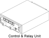
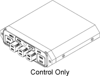
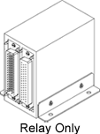
The ACU units can be complete with control and relay built into one assembly or they can be separated depending on the part number. Some GPS systems and CDIs include internal relays. Therefore, only a control with switch is required. In this case, you would only purchase the Control Head. Some installations use different custom sizes and styles of annunciator switches. Therefore, in this case, only a remote relay is purchased without a control assembly.
 |
 |
 |
In addition to variations in switches, relays, and sizes, ACUs are engineered to be compatible with specific GPS systems by different manufacturers. Variations in power input and bezel orientation are available as well.
What is the function and reason for annunciators required in an IFR GPS installation?
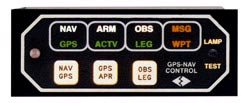
TERM - light that will signal pilot when operating within 30 miles of departure or arrival airport (i.e. Terminal area)
APR - light that signals pilot when the GPS is engaged in Approach mode
MSG - light that signals pilot that the GPS has generated a Message alert that should be viewed on the GPS
WPT - light that signals pilot that the GPS has generated a Waypoint alert that should be viewed on the GPS
INTG - light that will signal pilot when the GPS receiver detects a position error or is unable to calculate the Integrity of the position
Some annunciator units and annunciator control units or ACUs have a variety a these switches and annunciators depending on the GPS system to be interfaced with or the aircraft installation. However, there are certain annunciations such as MSG and WPT that are standard for all annunciators required.

I need an affordable IFR GPS system, which one should I purchase?
See this PDF document for a detailed listing of currently available IFR GPS systems and a brief comparison.

