
| Part #: | |
|---|---|
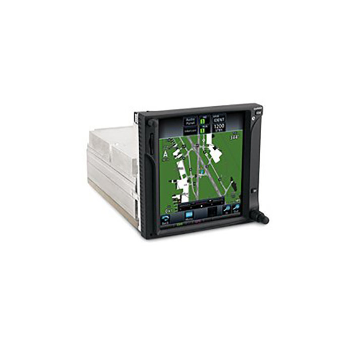
| Model: | GTN-725 |
| Desc: | WAAS GPS - Touchscreen |
| OEM: | Garmin |
| NSN: | |
|---|---|
| Sched-B: | 8526910010 |
| ECCN: |
| Price | Condition | Availability | Stock Info | |
|---|---|---|---|---|
| Price | Cond. | Avail. | Stock Info | |
| INSTALL ONLY | NEW | INSTALL ONLY | Send Install RFQ |
| Price | Condition | Availability | Stock Info | |
|---|---|---|---|---|
| Price | Cond. | Avail. | Stock Info | |
| $10,500.00 | SV OUTRIGHT | 4 IN STOCK |
Serial #: 1Z9010492 [Details]
Serial #: 1Z9010378 [Details]
See More Stock
|
|
| $2,750.00 | SV EXCHANGE | 4 IN STOCK |
Serial #: 1Z9010492 [Details]
Serial #: 1Z9010378 [Details]
See More Stock
|
FEATURES
- 6" Touchscreen WAAS GPS (GPS only version) with Multifunction Display capabilities
- Menu-driven graphical interface on color LCD touchscreen display
- 6.9" diagonal high-resolution TFT display
- On screen alphanumeric entry options
- Designed with raised grips in the bezel and a shelf across the lower edge that serve as gripping points during flight conditions
- Feature-rich MFD capabilities: moving map, chart display, airways, approaches & more
- High resolution terrain mapping - including topography features, cities, airports, terminal areas, SUAs and more
- GPS TSO'd to C146c, authorized for Class 1, 2, 3 (LPV)
- GPS WAAS-certified to Gamma-3 approach capability
- WAAS-corrected GPS signal accuracy to 1 M RMS
- Graphical flight planning (including airway navigation)
- Edit your entire route on the map screen and easily enter new or modify existing waypoints
- Extensive optional interface capabilities: lightning, weather, traffic, TAWS-B terrain alerting, and more
- Integrated control/display for remote transponder
- Flight control system interface for select autopilots
- Integrated control for remote audio panel functions
- Optional XM WX satellite weather and XM Radio
- SafeTaxi airport diagrams
- OPTIONAL - coupled with GDL-69 series datalink receiver - overlay NEXRAD radar right onto your moving map display and receive satellite music
- Features a front-loading SD card reader - easily update your databases
- The 16 Watt COM Enablement Card, Garmin P/N 010-00878-04, is to be used on 28 VDC aircraft only
*OPTIONAL Class A TAWS, ADS-B Out software upgrade available at additional cost, P/N: 010-00878-05
SPECIFICATIONS
| Dimensions: | 6.25"W x 6.00"H x 11.25"D | Display Size: | 4.46"W x 5.27"H |
| Display Resolution: | 600 x 708 pixels | Display Type: | Color TFT LCD; sunlight readable |
| Weight: | 7.7 lb | Voltage Range: | 11-33 |
| Built-in VHF Comm: | No | Transmit Power: | no (VHF comm not included) |
| Built-in VOR/LOC/GS: | No | Receiver: | 15 channel; TSO-C146c |
| IFR or VFR: | IFR | Basemap: | Yes |
| US Terrain & Obstacle Database: | Yes | Nav Database: | Yes |
| Types of Jeppesen Data: | Full & Non-Precision approaches, DPs and STARs, Victor/Jet Airways, eCharts (w/Optional Enablement) | Nav Database Coverage Area: | Americas, International or Worldwide |
| Waypoints/ Favorites/ Locations: | 1000 | Flight Plans: | 99 reversible; up to 100 waypoints each |
| Fly WAAS Approaches: | Yes | Moving Map: | Yes |
| Front-Loading Datacards: | Yes | XM WX Weather & Radio for US & Canada Compatible: | Yes |
| TIS Alerting Compatible: | Yes | Class B TAWs Alerting Compatible: | Yes |
| Additional: | Eligible for PilotPak Databases |
| Part Number: | Description: |
|---|---|
| 010-00819-50 | Black receiver w/rack, backplate, conn kit, config module & product info kit, Audio Panel |
| 011-02281-00 | Black receiver, 11-33 VDC, Audio Panel |
| Price | Condition | Status |
|---|---|---|
| $10,500.00 | SV OUTRIGHT | 4 IN STOCK |
| $2,750.00 | SV EXCHANGE | 4 IN STOCK |
| Price | Condition | Status |
|---|---|---|
| REQUEST | NEW | INSTALL ONLY |
Click on a question below to see the answer. If you have a question about this model that is not answered below, please contact questions@seaerospace.com
Why do some parts indicate "REQUEST" or “RFQ” on the Southeast Aerospace website?
In relation to NE (New) parts, many OEMs change their prices and availability without any notice to dealers or the industry. Therefore, through the REQUEST or RFQ indication, we ask that customers contact us for the most accurate price and availability.
In relation to SV & OH parts, the used parts aftermarket in the aviation industry is not an infinite supply. It is a dynamic, constantly changing market that is significantly affected by and susceptible to highs and lows in supply and demand. Therefore, although we attempt to, at times, we are unable to predict the exact moment when an item may be available. Once again, through the REQUEST or RFQ indication on our website, we ask that customers contact us for the most current and accurate price and availability.
What is the difference between the serial number and system ID on my GTN-725?
The serial number on all of our products is necessary for registration and warranty purposes. The system ID is an internal number which is required for database updates and downloads. These updates can be done on the Fly Garmin website. Each aviation database update is downloaded specific to the system ID of each GPS, therefore if the system ID is incorrect on our website, your aviation databases will not update correctly.
Why am I getting an error "0" when I run my aviation database program?
This error "0" is associated with the database program running on a computer that is not running a supported operating system. For the program to work correctly, the file must be downloaded on a computer running Windows XP or newer.
Why am I receiving a glide slope on a GPS LNAV Lateral Navigation (LNAV+V) approach?
The glide path that is generated is based on the information that is used for the Localizer Performance with Vertical guidance (LPV) and Lateral Navigation / Vertical Navigation (LNAV/VNAV) procedures. It uses a specified decent angle that is centered at the MAWP (Missed Approach Waypoint) and at the TCH (Threshold Crossing Height). If this information is included in the electronic database for the approach, the 400W/500W series, G1000 with WAAS, and GTN 600/700 series will generate a glide slope.
When updating databases, why doesn't my computer recognize my SD card?
This error message can result from a wide variety of issues. Below is a list of the most common:
- The SD card may be write protected. When write protected, data cannot be written to the SD card. On the SD card there is a small locking mechanism that can slide up and down. To be unlocked, the locking tab should be closer to the metal contacts on the SD card. Furthermore, the process of inserting the SD card into your Garmin device and/or SD card programmer may move the locking tab out of place.
- The card programmer cannot read or write to a high capacity card. Some card programmers cannot handle high capacity SD cards without a software download or driver update.
- There is an error or bad data region on the SD card. Perform an error checking scan of the card through Windows to correct the errors.
Why is the altitude on GTN-725 different than the altitude on my altimeter?
An altimeter does not measure altitude on the GTN-725 device. The altimeter in the aircraft measures air pressure. The altimeter is calibrated to display a certain change in altitude based on a change in air pressure. For every inch of mercury pressure change, the altimeter displays a change of approx. 1000 ft. of altitude. The GPS does not use air pressure to determine altitude and is not subject to the pressure errors in determining altitude. Therefore, the GPS derived altitude is almost always more accurate than an altimeter. Since everyone uses a pressure-based system to determine altitude, it is integral to utilize a pressure sensitive altimeter to ensure required vertical separation.
What is the meaning of the N in some Garmin part numbers?

