| Part #: | |
|---|---|
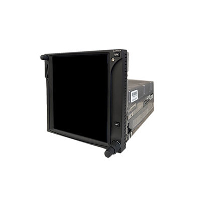
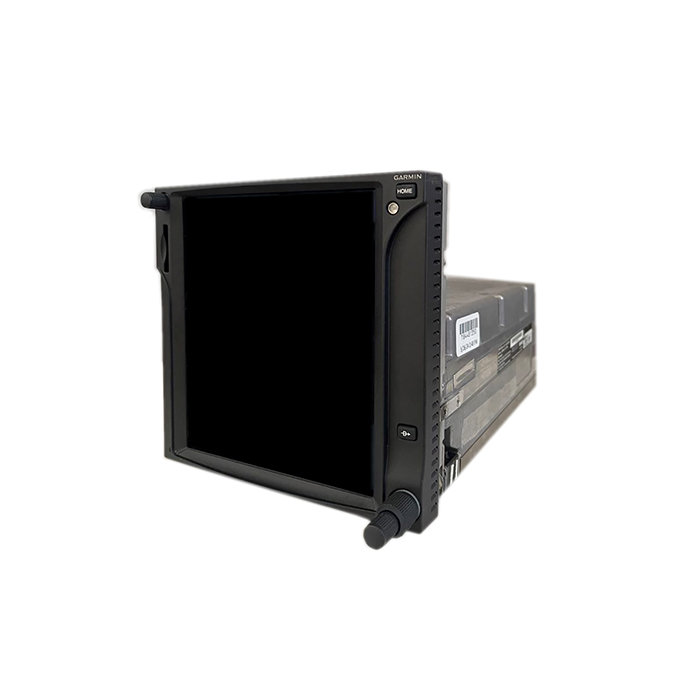
| Model: | GTN-750 |
| Desc: | WAAS GPS/Nav/Comm - Touchscreen |
| OEM: | Garmin |
| NSN: | |
|---|---|
| Sched-B: | 8526910070 |
| ECCN: | |
| Cage Code: | 0TRC3 |
| Price | Condition | Availability | Stock Info | |
|---|---|---|---|---|
| Price | Cond. | Avail. | Stock Info | |
| INSTALL ONLY | NEW | INSTALL ONLY | Send Install RFQ |
| Price | Condition | Availability | Stock Info | |
|---|---|---|---|---|
| Price | Cond. | Avail. | Stock Info | |
| $12,450.00 | SV OUTRIGHT | 2 IN STOCK |
Serial #: 1ZA014788 [Details]
Serial #: 1ZA015448 [Details]
|
|
| $3,450.00 | SV EXCHANGE | 2 IN STOCK |
Serial #: 1ZA014788 [Details]
Serial #: 1ZA015448 [Details]
|
| Price | Condition | Availability | Stock Info | |
|---|---|---|---|---|
| Price | Cond. | Avail. | Stock Info | |
| $10,450.00 | SV OUTRIGHT | 2 IN STOCK |
Serial #: 1ZA210519 [Details]
Serial #: 1ZA210122 [Details]
|
|
| $2,450.00 | SV EXCHANGE | 2 IN STOCK |
Serial #: 1ZA210519 [Details]
Serial #: 1ZA210122 [Details]
|
GTN 750
- 6" Touchscreen WAAS GPS/NAV/COMM with Multifunction Display capabilities
- Menu-driven graphical interface on color LCD touchscreen display
- 6.9" diagonal high-resolution TFT display
- On screen alphanumeric entry options
- Designed with raised grips in the bezel and a shelf across the lower edge that serve as gripping points during flight conditions
- Feature-rich MFD capabilities: moving map, chart display, airways, approaches & more
- High resolution terrain mapping - including topography features, cities, airports, terminal areas, SUAs and more
- Visual Approaches, with lateral and vertical guidance
- Ability to control the GTX-3000 transponder for TCAS II aircraft (note: this is not a TCAS II certified display)
- Support for forwarding GTX attitude through the Flight Stream 510 to portable devices
- GPS TSO'd to C146c, authorized for Class 1, 2, 3 (LPV)
- GPS WAAS-certified to Gamma-3 approach capability
- WAAS-corrected GPS signal accuracy to 1 M RMS
- Built-in GPS/ILS/VOR/LOC and glideslope capabilities available
- Graphical flight planning (including airway navigation)
- Edit your entire route on the map screen and easily enter new or modify existing waypoints
- VHF COMM transceiver: 8.33 or 25 kHz channel spacing
- Recent & favorite user frequencies are easily accessed
- Holding down the volume knob will automatically dial in the emergency frequency
- Com transmit power: 10W standard, 16W optional
- Extensive optional interface capabilities: lightning, weather, traffic, TAWS-B terrain alerting, and more
- Integrated control/display for remote transponder
- Integrated control for remote audio panel functions
- Flight control system interface for select autopilots
- Optional XM WX satellite weather and XM Radio
- SafeTaxi airport diagrams
- OPTIONAL - coupled with GDL-69 series datalink receiver - overlay NEXRAD radar right onto your moving map display and receive satellite music
- Features a front-loading SD card reader - easily update your databases
- The 16 Watt COM Enablement Card, Garmin P/N 010-00878-04, is to be used on 28 VDC aircraft only
OPTIONAL Class A TAWS, ADS-B Out software upgrade available at additional cost, P/N: 010-00878-05
Click Here to view a detailed comparison of the GTN-750 vs. GNS-530W
SPECIFICATIONS
| Dimensions: | 6.25"W x 6.00"H x 11.25"D | Display Size: | 4.46"W x 5.27"H |
| Display Resolution: | 600 x 708 pixels | Display Type: | Color TFT LCD; sunlight readable |
| Weight: | 9.3 lb | Voltage Range: | 11-33 |
| Built-in VHF Comm: | Yes | Transmit Power: | 10 watts min, 16 wast min (optional) |
| Built-in VOR/LOC/GS: | Yes | Receiver: | 15 channel; TSO-C146c |
| IFR or VFR: | IFR | Basemap: | Yes |
| US Terrain & Obstacle Database: | Yes | Nav Database: | Yes |
| Types of Jeppesen Data: | Full & Non-Precision approaches, DPs and STARs, Victor/Jet Airways, eCharts (w/Optional Enablement) | Nav Database Coverage Area: | Americas, International or Worldwide |
| Waypoints/ Favorites/ Locations: | 1000 | Flight Plans: | 99 reversible; up to 100 waypoints each |
| Fly WAAS Approaches: | Yes | Moving Map: | Yes |
| Front-Loading Datacards: | Yes | XM WX Weather & Radio for US & Canada Compatible: | Yes |
| TIS Alerting Compatible: | Yes | Class B TAWs Alerting Compatible: | Yes |
| Additional: | Eligible for PilotPak Databases |
| Part Number: | Description: |
|---|---|
| 011-02282-00 | NAV/COMM/WAAS Navigator, Black |
| 011-02282-50 | NAV/COMM/WAAS Navigator, Gray |
| 011-02282-A0 | NAV/COMM/WAAS Navigator, Night Vision, Black |
| Price | Condition | Status |
|---|---|---|
| $10,450.00 | SV OUTRIGHT | 2 IN STOCK |
| $2,450.00 | SV EXCHANGE | 2 IN STOCK |
NSN: 5826-01-686-0294
| Price | Condition | Status |
|---|---|---|
| $12,450.00 | SV OUTRIGHT | 2 IN STOCK |
| $3,450.00 | SV EXCHANGE | 2 IN STOCK |
NSN: 5895-01-614-7634
| Price | Condition | Status |
|---|---|---|
| REQUEST | NEW | INSTALL ONLY |
Click on a question below to see the answer. If you have a question about this model that is not answered below, please contact questions@seaerospace.com
What are some of the differences between the GTN-650/750 and GTN-650Xi/750Xi
The GTN Xi navigators provide several improvements over the original GTN navigators including a dual processor and updated LCD screen.
The upgraded processor enables the Xi to be faster than the original GTN. The updated screen improves the resolution from 134 DPI to 187 DPI.
Some of the other minor differences include:
- Location of buttons on the Xi were moved closer to the bottom right knob
- All databases stored internally on the Xi
- The Xi is lighter in weight
- The Xi draws less current
Why do some parts indicate "REQUEST" or “RFQ” on the Southeast Aerospace website?
In relation to NE (New) parts, many OEMs change their prices and availability without any notice to dealers or the industry. Therefore, through the REQUEST or RFQ indication, we ask that customers contact us for the most accurate price and availability.
In relation to SV & OH parts, the used parts aftermarket in the aviation industry is not an infinite supply. It is a dynamic, constantly changing market that is significantly affected by and susceptible to highs and lows in supply and demand. Therefore, although we attempt to, at times, we are unable to predict the exact moment when an item may be available. Once again, through the REQUEST or RFQ indication on our website, we ask that customers contact us for the most current and accurate price and availability.
How can I safely clean and disinfect my Garmin avionics?
Garmin has provided Service Advisory 2051 for general recommendations, materials, and supplies to clean and disinfect Garmin products. Otherwise, not following the recommendations could void the warranty.
- Cleaners containing ammonia will harm the anti-reflective coating on many Garmin aviation display lenses.
- Disinfectant with a solution of 70% isopropyl alcohol that does not contain ammonia is preferred. Solutions of up to 91% isopropyl alcohol are also acceptable.
- Clean the display lens using a clean lint-free cloth and a cleaner that is specified as safe for anti-reflective coatings.
- For other exposed surfaces such as knobs, buttons, and bezels, a damp cloth with soap and water is acceptable.
- Bleach-based cleaners, ammonia-based cleaners, or other harsh chemicals on any surface are not recommended.
- Remove all soap/soap residue to prevent buttons and knobs from gumming up or becoming slippery.
- Many aviation products are not rated as waterproof. Spraying or wetting the units to the extent where moisture could go beyond the exterior surfaces could damage the unit.
I want to upgrade my PA24-260 Piper Comanche nav/com to a GNS-530W as well as making it ADS-B in/out compliant. What transponder and other components are required?
First, we would recommend contacting a local Garmin dealer to discuss the following:
- Upgrading your existing nav/com to a used GNS-530W or the newer GTN-750.
- If you already have a Garmin transponder (i.e. GTX-330), then you should simply get the ES upgrade, interface to GNS-530W or GTN-750, along with a few other minor installation considerations, and get the shop to do the appropriate paperwork based on Garmin's AML STC.
- If you do not have the GTX-330, then you should just consider pursuing one of the GDL systems from Garmin. Most likely the GDL88 which will give you In/Out capability. Same interface and installation considerations as above apply. Please note ADS-B In is not required for the mandate.
Why is the altitude on my GTN-750 different than my altimeter?
An altimeter does not measure altitude on the Garmin GPS device. The altimeter in the aircraft measures air pressure. The altimeter is calibrated to display a certain change in altitude based on a change in air pressure. For every inch of mercury pressure change, the altimeter displays a change of approx. 1000 ft. of altitude. The GPS does not use air pressure to determine altitude and is not subject to the pressure errors in determining altitude. Therefore, the GPS derived altitude is almost always more accurate than an altimeter. Since everyone uses a pressure-based system to determine altitude, it is integral to utilize a pressure sensitive altimeter to ensure required vertical separation.
How do I access recently used frequencies on the GTN-750?
To view a list of frequencies which have recently been in the "Active" Communications Frequency box on the GTN, follow the steps below:
- Select the "STBY" or Standby Communications Frequency box
- On the next screen, touch the "Find" icon
- A list of "Recent Communication Frequencies" will appear
- If it is necessary to utilize one of the frequencies, touching the appropriate frequency will automatically place it in the "STBY" communication box
If a particular frequency is used often, it may be helpful to take advantage of the recent communications feature to call-up the appropriate frequency.
How do I download databases to my GTN-750?
To update your GTN-635 with current databases log in to our website www.flyGarmin.com. On the flyGarmin website, find the tabs along the top of the screen and follow the steps below:
1. Click the "Aircraft" tab
2. Click "Add an Aircraft" from the right hand side of the page.
3. Fill out all required information: Make, Model, Series, Tail number, Year, Serial Number
4. Click "Add Aircraft"
5. Click on "Add a new aircraft device" under What can I do?
6. Select the make and model of Garmin equipment
7. Enter the System ID or Serial number
8. Click on any of the database names to the left of the picture of your equipment
9. Click the "Buy Databases" button
10. Click "Buy" again
11. Click the "Download Now" button once the database has been purchased
12. On the flyGarmin website, click the "INSTALL" button. The website will automatically start to update your unit.
Where can I find the system ID on a GTN-6XX/7XX?
The system ID is required for aviation database updates which are downloaded from www.flygarmin.com. The database updates download specific to the system ID of each GTN so it is important this number is correct.
Follow the steps below to locate the system ID, from the 'Home' screen on the GTN:
- Touch the 'System' icon
- Select 'System Status'
- At the top of the 'System Status' page, the 'System ID ' is the second number listed
Once this number is copied correctly, log on to the FlyGarmin website and add the appropriate GTN to an aircraft on the account. Once the GTN is added, databases will be available for purchase and then ready for download.
What is the difference between the serial number and system ID on my aviation GPS?
The serial number on the product is necessary for registration and warranty purposes. The system ID is an internal number which is required for database updates and downloads. These updates can be completed at www.flygarmin.com. Each aviation database update is downloaded specific to the system ID of each GPS, therefore if the system ID is incorrect on our website, your aviation databases will not update correctly.
Why am I getting an error "0" when running the aviation database program?
Error "0" is associated with the database program running on a computer that is not running a supported operating system. For the program to work correctly, the file must be downloaded on a computer running Windows XP or newer.
Why is there a glide slope on a GPS LNAV Lateral Navigation (LNAV+V) approach?
The glide path that is generated is based on the information that is used for the Localizer Performance with Vertical guidance (LPV) and Lateral Navigation / Vertical Navigation (LNAV/VNAV) procedures. It uses a specified decent angle that is centered at the MAWP (Missed Approach Waypoint) and at the TCH (Threshold Crossing Height). If this information is included in the electronic database for the approach, the 400W/500W series, G1000 with WAAS, and GTN 600/700 series will generate a glide slope.
When updating databases, why is my computer not recognizing my SD card?
The error message can result from a wide variety of issues. Below is a list of the most common issues:
- The SD card may be write protected. When write protected, data cannot be written to the SD card. On the SD card there is a small locking mechanism that can slide up and down. To be unlocked, the locking tab should be closer to the metal contacts on the SD card. Furthermore, the process of inserting the SD card into your Garmin device and/or SD card programmer may move the locking tab out of place.
- The card programmer cannot read or write to a high capacity card. Some card programmers cannot handle high capacity SD cards without a software download or driver update.
- There is an error or bad data region on the SD card. Perform an error checking scan of the card through Windows to correct the errors.
What is the meaning of the N in some Garmin part numbers?
Does the GTN 750 replace the discontinued GNS-530W? What is the difference between the two?
The GTN 750 is a replacement for the GNS-530W. You can compare the two units here

